
Acropole-des-Draveurs, Grands-Jardins, Sentier des Caps, Le Massif: guide to the best hikes in Charlevoix from La Malbaie.
Charlevoix is a geological accident that turned out remarkably well. Four hundred million years ago, a two-kilometre-wide meteorite struck the Canadian Shield here, carving a 56-kilometre crater that shaped essentially all of the region's topography. The result: granite walls exceeding 800 metres, deep valleys cut by glacial rivers, and a patchwork of microclimates that places Arctic tundra alongside hardwood forest within a few kilometres. For hikers, the density is extraordinary — seven major trail networks, all within an hour's drive of Cap-à-l'Aigle, La Malbaie.
Acropole-des-Draveurs: Quebec's iconic hike
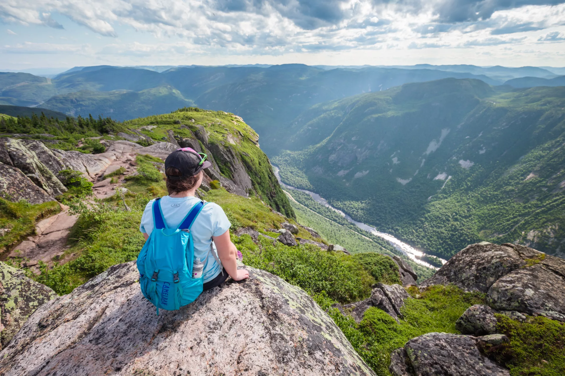
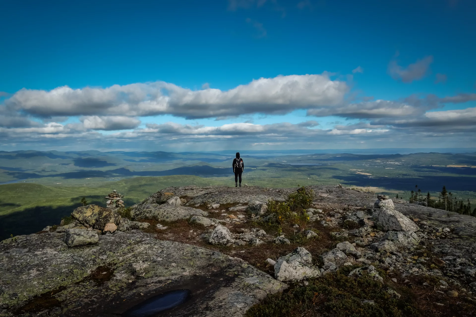
The Parc national des Hautes-Gorges-de-la-Rivière-Malbaie has seven hiking trails, but it is the Acropole-des-Draveurs that draws hikers from across Quebec. The trail climbs 800 metres of elevation over a relatively short distance, passing from dense boreal forest to bare granite at altitude. The ascent is relentless — no false flats to catch your breath — and the final stretch crosses exposed rock slabs open to the wind. The summit view earns every step: the Malbaie River gorges seen from above, the boreal forest stretching to the horizon, and on clear days, the St. Lawrence River in the distance.
This is a difficult trail — good physical fitness is required, and you should allow four to six hours for the round trip. But the park also offers gentler options for those who want the scenery without maximum exertion. The Deux-Belvédères trail, rated easy, follows the Malbaie River with viewpoints of the cliff faces and little elevation gain. The Le Riverain trail offers a leisurely walk along the valley floor.
Access is through the Centre de découverte et de services Félix-Antoine-Savard, via Saint-Aimé-des-Lacs. The SÉPAQ daily access fee is mandatory and reservations are recommended in peak season, as visitor numbers are capped. The park is approximately 40 minutes from your base in Cap-à-l'Aigle.
Parc national des Grands-Jardins: walking on tundra
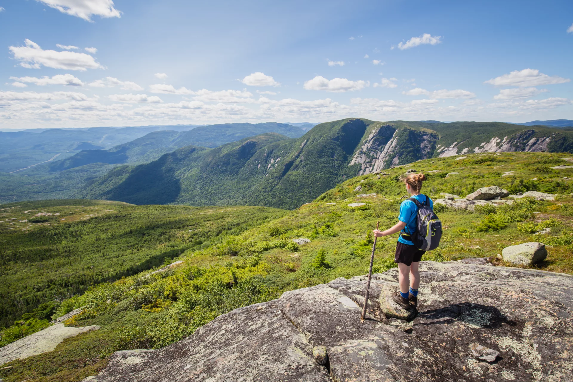
The Parc national des Grands-Jardins is the only place south of the 50th parallel where you can walk through a landscape of taiga and Arctic tundra — a direct legacy of the altitude and microclimate created by the meteorite crater. The trail network exceeds 30 kilometres and crosses a succession of natural environments that change dramatically every few kilometres: hardwood forest, boreal forest, montane vegetation and lichen tundra.
The signature hike is Mont du Lac-des-Cygnes. The ascent leads to a summit with a unique vantage point over the Charlevoix meteorite crater and the Gros-Bras valley. You walk, quite literally, on the rim of the astrobleme, surrounded by caribou that have been reintroduced to the park — Grands-Jardins is home to one of the last herds south of the St. Lawrence. The sparse tundra vegetation gives the impression of standing in the Far North, barely two hours from Quebec City.
Access is from Route 381, at kilometre 21, via Saint-Urbain. As with Hautes-Gorges, the SÉPAQ access fee is mandatory and reservations are strongly recommended in summer. The park is approximately 50 minutes from the chalet, heading toward Saint-Urbain.
Sentier des Caps: the grand traverse above the river
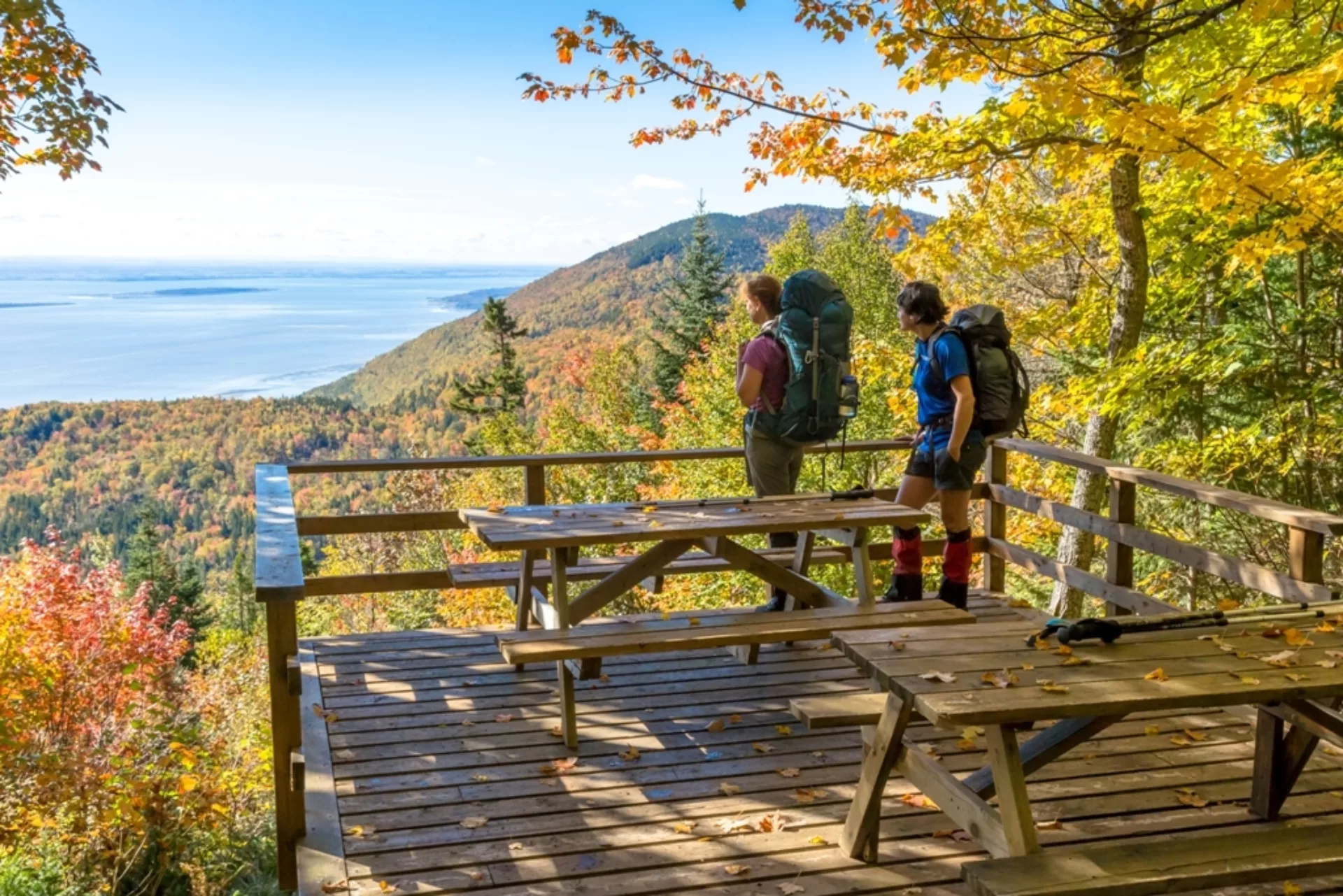
The Sentier des Caps de Charlevoix is the region's most spectacular long-distance trail network. With 28 kilometres of day-hiking trails and a 51-kilometre through-hike, it caters to everything from a half-day outing to a multi-day trek with hut accommodation. The total network spans 74.9 kilometres, with difficulty levels ranging from easy to challenging.
What sets the Sentier des Caps apart is its geography: the trails run along the crest of the capes overlooking the St. Lawrence River, with plunging views of the water and the islands below. The hiking alternates between forest and open lookouts, with rolling terrain that mixes sustained climbs and ridgeline passages. In autumn, when the colours set the capes ablaze on either side, the scenery rivals the finest trails in North America.
The main welcome centre is at 2, rue Leclerc in Saint-Tite-des-Caps. The network is open from mid-June to April, with an entry fee. The Sentier des Caps is approximately one hour from the chalet, heading toward Quebec City — the farthest destination in this selection, but well worth the drive for anyone who appreciates ridgeline walking above the river.
Le Massif de Charlevoix: 20 free kilometres facing the St. Lawrence
Le Massif de Charlevoix, known in winter for the highest vertical drop in eastern Canada, transforms in summer into a 20-kilometre hiking network with sweeping views of the St. Lawrence River. Trailheads at both summit and base offer options for all levels. The best part: hiking at Le Massif is free.
The mountain's position, facing the river, creates a visual effect that few mountains in Quebec can match. You walk at altitude with the St. Lawrence below, ships passing in the distance and, on clear days, the south shore tracing the horizon. The trails wind through a mixed forest where the air carries the scent of spruce and yellow birch.
Le Massif is in Petite-Rivière-Saint-François, approximately 35 minutes from the chalet.
Mont Gabrielle-Roy: a 360-degree panorama over the valley
The Sentier Gabrielle-Roy takes its name from the celebrated Quebec novelist who spent her summers in Petite-Rivière-Saint-François. The climb — steeper from the west than from the east — leads to a summit with a 360-degree panorama over the region: the mountains of Parc national des Grands-Jardins, the Hautes-Gorges-de-la-Rivière-Malbaie, Mont Grand-Fonds, Mont des Éboulements, Isle-aux-Coudres, Le Massif de Charlevoix and the Gouffre valley. It is one of the rare summits in Charlevoix that allows you to take in the full scope of the landscape shaped by the meteorite impact.
The trail is rated intermediate and suits hikers looking for a half-day outing with solid elevation gain but without the length of the Acropole-des-Draveurs. The trailhead is accessible from Petite-Rivière-Saint-François, approximately 40 minutes from the villa.
Mont Grand-Fonds: a hike fifteen minutes from La Malbaie
Mont Grand-Fonds is the most accessible hike from the chalet — barely fifteen minutes by car. Three trails are on offer: La Sommet, an intermediate-level climb; La Trappeur, a more demanding and technical 3.8-kilometre ascent to the Lac Gravel lookout; and La Familiale, an easy route suited to casual walkers and families.
The mountain, less well known than the national parks, has a particular charm. In summer, the scent of spruce fills the trails, and the summit lookout offers an open view over the Malbaie River valley. It is the ideal hike for an afternoon when you would rather not drive an hour before walking — leave the chalet, climb, come back down, and be home in time for the barbecue on the terrace. It is also, every mid-September, the finish line of the Ultra-Trail Harricana, Charlevoix's major trail race.
La Traversée de Charlevoix: the ultimate backcountry traverse
For experienced hikers who want to go further, La Traversée de Charlevoix is a 105-kilometre backcountry traverse designed for three, four or seven days depending on pace. The route crosses mountainous terrain through boreal forest, highland lakes and exposed ridges, with huts and cabins available along the way. The total network reaches 175.7 kilometres including variants and shorter trails connected to the main route.
The Traversée is for intermediate to advanced hikers — the terrain is demanding, the days are long and self-sufficiency is essential. Registration is at kilometre 10.6 on Route 381 in Saint-Urbain, with the trail starting at kilometre 27. The route is open year-round, with cabin rental available.
This is hiking on a different register from the day trip — several days of complete immersion in the Charlevoix backcountry, with the rare feeling of being alone in a territory as vast as it is wild.
Planning your hikes from the chalet
A few practical notes. The hiking season runs from June to October, with peak traffic in July–August and a spectacular burst of autumn colour from late September to mid-October. The national parks (Hautes-Gorges and Grands-Jardins) require advance reservation through the SÉPAQ website — do not set out without booking in peak season, as access is limited.
For families, Le Massif (free, varied trails) and La Familiale at Mont Grand-Fonds (15 minutes from the chalet) are the simplest options. For intermediate hikers, Mont Gabrielle-Roy and the Sentier des Caps offer the best effort-to-panorama ratio. For serious hikers, the Acropole-des-Draveurs remains the summit to reach — though consider going on a weekday to avoid the summer weekend crowds.
Bring one to two litres of water per person, ankle-support hiking boots for the more technical trails, sunscreen and insect repellent. Weather conditions can change quickly in the mountains — always carry an extra layer, even when the sun is shining at the trailhead.
To round out your outdoor trip, see our guide to vertical activities in Charlevoix or browse all outdoor activities in the region.
After a day of elevation gain, coming back to the Le Littoral chalet with sauna and outdoor spa, in Cap-à-l'Aigle, is the ideal reward: under an hour from most of these summits, it is where tired legs recover to the sound of the river.